Lighthouses of Sweden: Valdemarsvik to Landsort

This page covers lighthouses of Svealand in eastern Sweden in the counties of Östergötland and Södermanland. These counties face eastward on the Baltic Sea just to the south of the Stockholm area.

The Swedish word for a lighthouse is fyr. The front light of a range is the nedrefyr (lower light) and the rear light is the övrefyr (upper light). Aids to navigation in Sweden are maintained by the Swedish Maritime Administration (Sjöfartsverket). Many of the major lighthouses have resident attendents, and guided tours can often be arranged. The Swedish Lighthouse Society (Svenska Fyrsällskapet) works for the preservation of the lighthouses.

ARLHS numbers are from the ARLHS World List of Lights. SV numbers are from the Sjöfarsverket light list (Fyrlista) as reported by the Swedish Lighthouse Society. Admiralty numbers are from volume C of the Admiralty List of Lights & Fog Signals. U.S. NGA List numbers are from Publication 116.

General Sources
Swedish Lighthouse Society (Svenska Fyrsällskapet, SFA)
The Society has a large web site, and some of the information is available in English as well as Swedish. An interactive map links to pdf pages (in Swedish) for the major lighthouses, and there is a list of photos available.
Lighthouses in Sweden
Aerial photos posted by Marinas.com.
Lighthouse Pages from Anke and Jens - Sweden
Photos and brief accounts (in English) by two German lighthouse fans.
Henning Jensen's Lighthouse Pages
Photos and comments for about 20 lighthouses, posted by an employee of the Maritime Administration who helps maintain the lighthouses.
Swedish Lighthouse Selection Page
Photos posted by Pete Amass.
Fyrar
Photos taken from the sea, posted by Bosse Arnholm.
Fyr Vi Har Passeret (Lighthouses We've Passed)
Photos of Baltic lighthouses taken by two Danish sailors, Jette and Ole.
Schwedische Leuchttürme auf historischen Postkarten
Historic postcard views posted by Klaus Huelse.

Kopparholmen Lighthouse
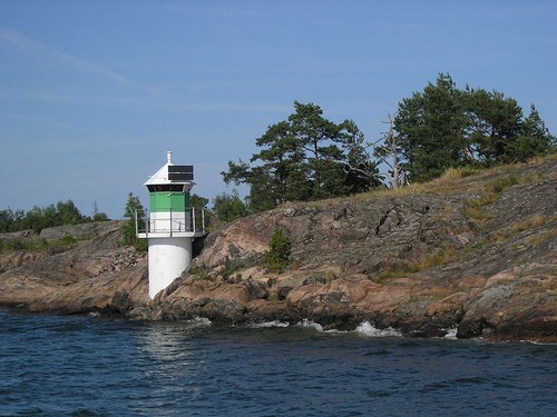
Kopparholmen Fyr, July 2006
anonymous Creative Commons photo

Lighthouses of Östergötlands län (Östergötland county)

From the mouth of Valdemarsviken to Jungfrusalen outside Slätbaken
Ljusklabb
Q WRG
Svartbåden
1940. Active; focal plane 8 m (26 ft); three flashes every 9 s, white, red or green depending on direction. 7 m (23 ft) round tower with lantern and gallery, painted white with a narrow red band under the gallery. SFA has a photo by D. Erikkson, and distant view is available. Located on the eastern tip of a small island off the coast of Stora Ålö. Accessible only by boat. Site open, tower closed. SV-5182; Admiralty C7032; NGA 8388.
Halsöklabb
Fl WRG 3s
Hägerökarten
1940. Active; focal plane 10 m (33 ft); four flashes every 12 s, white, red or green depending on direction. 10 m (33 ft) round cylindrical concrete tower with lantern and gallery, painted white with a black band around the base. (NGA says there is also a green horizontal band, but this is not seen in the photo.) Located on a skerry about 4 km (2.5 mi) south southwest of Fångö. Accessible only by boat. Site open, tower closed. ARLHS SWE-167; Admiralty C7026; NGA 8396.
Häradskär
1863 (Nils Gustaf von Heidenstam). Active; focal plane 36 m (118 ft); three long (2.5 s) white flashes every 20 s. 29.5 m (96 ft) round cast iron skeletal tower with lantern, gallery, and central cylinder. Entire lighthouse painted red. The original rotating 1st order fresnel lens was replaced in 1978 by a 3rd order lens transferred from the Dämman lighthouse (see Southeastern Sweden). It appears that the keeper's houses have been demolished. SFA has a photo by E. Hilberg, another more distant photo is available, Marinas.com has aerial photos, and Huelse has a historic postcard view. This historic lighthouse, one of von Heidenstam's earliest designs, lives a lonely life far out in the Baltic. Nearby are the ruins of a daybeacon built in 1745. Located on a small island about 4 km (2.5 mi) southeast of Fångö. Accessible only by boat. Site open, tower closed. ARLHS SWE-180; SV-5163; Admiralty C7022; NGA 8400.
Sandö
1940. Active; focal plane 12 m (39 ft); two long (2 s) flashes every 15 s, white, red or green depending on direction. 12 m (39 ft) round tower, probably with lantern and gallery, painted white with a green horizontal band and a black band around the base. No photo available. Located, probably on a skerry, about 1.2 km (3/4 mi) off the south coast of Fångö. Accessible only by boat. Site open, tower closed. Admiralty C6966; NGA 8432.
Kättilö
1940. Active; focal plane 4 m (13 ft); flash every 3 s, white, red or green depending on direction. 4 m (13 ft) octagonal lantern, painted white with one red horizontal band. A photo is available. Located on the northeast coast of Kättilö, marking the channel between that island and Fångö. Site status unknown. Admiralty C6964; NGA 8404.
Kvarnholmen
Fl(3) WRG 9s
Espskärsgrund
1940. Active; focal plane 4 m (13 ft); two flashes every 6 s, white, red or green depending on direction. 4 m (13 ft) octagonal lantern, mounted on a round concrete pier. Lantern painted white with one green horizontal band. A photo is available. Located about 1 km (0.6 mi) southwest of Håskö. Accessible only by boat. Site open, tower closed. Admiralty C6962; NGA 8408.
Stora Bockholmen (rear light together with Bockholmen)
Q
(North) Bockholmen
Iso 4s
Bergholmen
Q WRG
Snuggholmen (2) "I can only confirm one light called Snuggholmen?"
Date unknown (station established 1940). Active; focal plane about 11 m (36 ft); three flashes every 9 s, white, red or green depending on direction. Approx. 10 m (33 ft) post light mounted on a round cylindrical base. Base painted white with a narrow red horizontal band. A photo is available (third image on the page). SFA has a photo by S. Björnson showing the original appearance of the light. Located off the northeast point of the island Väggö. Accessible only by boat. Site open, tower closed. SV-5117; Admiralty C6954; NGA 8440.
Enskär
Fl WRG 3s
Sandsänkan
1931. Active; focal plane 15 m (49 ft); white, red or green light, depending on direction, 2 s on, 8 s off. 16 m (52 ft) round cylindrical concrete tower with lantern and gallery. Lighthouse painted black, lantern white. Marinas.com has aerial photos. Located in the Baltic Sea about 11,25 km (7 mi) due east of Enskär Light. A very lonely light surrounded by hardly visible skerries. Accessible only by boat. Site open, tower closed. Admiralty C6978; NGA 8424.
Fågelön
Q WRG
Ådkobb
Fl(2) WRG 6s
Stora Högholmen
Q Iso 4s
Lammskär
Iso 4s
(North) Lammskär (rear light together with Lammskär)
Q
Horvelsö
1940. Active; focal plane 4 m (13 ft); flash every 3 s, white, red or green depending on direction. 4 m (13 ft) octagonal lantern, painted white with one red horizontal band. SFA has a photo by D. Eriksson. Located on a skerry about 1200 m (3.4 mi) southwest of Aspöja. Accessible only by boat. Site open, tower closed. SV-5091; Admiralty C6984; NGA 8464.
Jungfrusalen
Q WRG


From Söderköping and Mem (entrance to Göta Canal) through Slätbaken to Bråviken
Söderköping
Fl WRG 3s
Lundbynäs
Q WRG
Hackerstad
Fl(2) WRG 6s
Stegeborg
Uncertain, probably red and green light buoys on each side of the fairway that passes through a very narrow strait.
Ettersundet (west)
        Q WRG
Ettersundet (east)
Fl WRG 3s
Fårholmen
Fl(4) WRG 12s
Björskär
1924. Active; focal plane 4 m (13 ft); flash every 3 s, white, red or green depending on direction. 5 m (17 ft) rectangular wood building, painted white with one red horizontal band. The light is shown through a narrow window. A photo is available. Located on a skerry in the Lönshuvudfjard about 2 km (1.2 mi) east southeast of Hummelvik. Accessible only by boat. Site open, tower closed. Admiralty C6976; NGA 8484.
Lönshuvud
1917. Active; focal plane 4 m (13 ft); two flashes every 6 s, white, red or green depending on direction. 4 m (13 ft) octagonal lantern, mounted on a concrete pad. Lantern painted white with one green horizontal band. A photo is available. Located on a promontory of the mainland, about 5 km (3 mi) east of Hummelvik. Site status unknown. Admiralty C6974; NGA 8480.

Norra Fällbådan
1955. Active; focal plane 16 m (52 ft); three flashes every 9 s, white, red or green depending on direction. 17 m (56 ft) round cylindrical concrete tower with lantern and gallery. Lighthouse painted black with one red horizontal band, lantern painted white. Located in the Baltic Sea about 8 km (5 mi) east southeast of Arkösund. Accessible only by boat. Site open, tower closed. Admiralty C6966; NGA 8428.
Kopparholmen
Date unknown (station established 1884). Active; focal plane 6 m (20 ft); white, red or green light, depending on direction, 2 s on, 2 s off. 6 m (20 ft) round tower with lantern and gallery, painted white with a green horizontal band around the lantern. A photo is at the top of this page, SFA has a photo by D. Eriksson, another photo is available, and Google has a satellite view. This light is the front light of a range guiding vessels northward to Arkösund; the Kuggviksskär light is the rear light. Located on the west point of Östra Kopparholmen, about 1.2 km (3/4 mi) south of the southeastern tip of Gränsö. Accessible only by boat. Site open, tower closed. SV-4846; Admiralty C6972; NGA 8520.
Arkö nedre (Östra Kopparholmen)
1932. Active; focal plane 8 m (26 ft); quick-flashing light, white, red or green depending on direction. 4 m (13 ft) octagonal lantern, mounted on a concrete pad. Lantern painted white with a red daymark on the range line. A photo is available, and Google has a satellite view. Located on the northeast coast of Östra Kopparholmen. Accessible only by boat. Site open, tower closed. Admiralty C6968; NGA 8528.
Kuggviksskär (Kopparholmen Övre)
1937. Active; focal plane 13 m (43 ft); four quick flashes every 6 s, white, red or green depending on direction. 12 m (39 ft) round cylindrical tower with lantern and gallery. Entire lighthouse painted white. SFA has a good photo by U. Völz, a 2008 photo and another photo are available, Marinas.com has aerial photos, and Google has a satellite view. The light guides vessels to Arkösund and is also the rear light of the Kopparholmen Range. Located on a skerry off the southeastern tip of Gränsö and about 2 km (1.2 mi) southeast of Arkösund. Accessible only by boat. Site open, tower closed. ARLHS SWE-224; SV-4845; Admiralty C6972.1; NGA 8524.
[Arkö Båk] (Navigation mark only)
1891. Never active as a lighthouse. 20 m (66 ft) square wood skeletal tower covered with steel plates. Upper half of the tower painted red, lower half white except red on the seaward face. The metal covering was added in 1927. In 2004, the Sjöfartsverket announced that this historic daybeacon would be demolished unless a local group was interested in maintaining it. The Arkö Båks Vänner was quickly formed, and in 2005-06 the tower was restored, with contributions from the Swedish Maritime Administration (50,000€), The National Heritage Board of Sweden (20,000€), and a historic preservation grant from the EU, "Goal 2 Islands" (25,000€). Arkö Båk is situated exactly 1 nautical mile northeast of Kuggviksskär Light (coarse 44,12 degrees). Accessible only by boat. Site open. Tower open on the International Lighthouse Weekend in August.
E-mail info@arkobak.se prior to a planned visit.
Viskär
1894. Inactive since 1932. Approx. 9 m (30 ft) octagonal tower with lantern and gallery, attached to the seaward end of a 1-1/2 story wood keeper's house. Lighthouse painted white, lantern black; house painted red with white trim. SFA has a photo by Esbjörn Hillberg, a good 2008 photo is available, and Google has a satellite view. The house is a private residence, and the owners have maintained the lighthouse in excellent condition. Located on an island about 2.5 km (1.5 mi) east of Arkösund. Accessible only by boat. Site and tower closed. Site manager: private. ARLHS SWE-324.
Karthällan
1958. Inactive since 1999. Approx. 8 m (26 ft) round cylindrical concrete tower with lantern and gallery. Formerly painted white, but nearly all the paint has disappeared. A closeup photo is available. Located on a skerry about 8 km (5 mi) northeast of Arkösund. Accessible only by boat. Site open, tower closed. ARLHS SWE-214; Admiralty C6853.
Liss Lindö
Fl WRG 3s
Ettergrundshällan
Oc WRG 6s
Gränsösund nedre (alone towards north northwest, front light together with Gränsösund övre towards southeast)
Iso WRG 4s
Gränsösund övre
Q
Trollholmshällan
Fl(2) WRG
Norra Gränsö
Fl WRG 3s
Bosöstenen
Fl(2) WRG 6s
Marö övre (alone towards west, rear light together with Marö nedre towards northeast)
Q WRG
Marö nedre
Iso WRG 4s
Ramsholmen övre
Oc 3s
Ramsholmen nedre
Q
Fläsköhällan
Fl(3) WRG 9s
Vivstagrund (Buoy east of fairway)
Q G
Vivstagrund (Light west of fairway)
Fl(2) RG 6s
Vivstagrund (Light northeast of fairway)
Fl RG 3s
Fläskögrund
Iso WRG 4s
Lönö
Fl WRG 4s


From Norrköping through Bråviken to west of Oxelösund
Stora Juten
Fl WRG 4s
Bodagrund (Buoy)
Fl G 3s
Kranåsen (buoy)
Fl R 3s
Lövsgata
Fl(2) WRG 6s
Algersgrund
Q WRG
Unnamed (Buoy)
Fl R 3s
Säterholmen
Fl(4) WRG 12s
Karlslund
Q WRG
Nävekvarn
Fl(2) WRG 6s
Hargökalv
Fl(4) WRG 12s
Unnamed (Buoy)
Fl R 3s
Gullängsberget (Buoy)
Fl(2) G 6s
Unnamed (Buoy) (south bypass fairlane)
Fl(2) G 6s
Mesen
Fl WRG 3s
Ålbäcksgrund
Fl(2) WRG 6s
Kungshamn Syd (Buoy)
Fl R 3s
Kungshamn nedre
Iso WRG 4s 10M
Kungshamn Övre
Date unknown (station established 1893). Active; focal plane 19 m (62 ft); quick-flashing light, white, red or green depending on direction. 9 m (30 ft) round cylindrical concrete tower with lantern and gallery, painted white with one red horizontal band. A very distant view is available. Located on the north side of the enrtamnce to Kungshamn, about 5 km (3 mi) southwest of Femöre. Site status unknown. Admiralty C6846; NGA 8660.
 
Kungshamnsgrund (south bypass fairlane)
Fl R 3s
Falkens Grund
Date unknown. Active; focal plane 10 m (33 ft); three flashes every 9 s, white, red or green depending on direction. 11 m (36 ft) tower with lantern. Tower painted white, lantern red. No photo available. Located on a shoal about 4 km (2.5 mi) southwest of Oxelösund. Accessible only by boat. Site open, tower closed. Admiralty C6845; NGA 8652.
Klasgrunden nordväst
Fl R 3s
Klasgrunden nord
Q
Klasgrunden öst
Q(3)
 

Lighthouses of Södermanlands län (Södermanland county)

Oxelösund Lighthouses
* Femörehuvud
1867. Inactive since 1974. A small, disused concrete beacon stands in front of the original 1-1/2 story wood keeper's house. Beacon painted white with a red horizontal band. The keeper's houses are available for overnight accommodations. A 2008 closeup of the beacon is available. Huelse has a historic postcard view of the house with original light, which was replaced by the concrete beacon in 1955. Nearby is the Femörefortet, a nuclear-safe fortress built to protect Sweden from a possible Soviet invasion during the Cold War. Femöre is an island, connected to the mainland by a causeway or narrow isthmus, south of Oxelösund. Located at the southern tip of Femöre. Accessible by road. Site open, tower closed. ARLHS SWE-129.
Vinterklasen
Mo ۠(· · —) WRG 10s 11M
Unnamed Buoy
Fl R 3s
Unnamed Buoy
Q R
Beten
Fl(2) WRG 6s 13M
Betens Södra Grund
Fl(2) G 6s
Sagas Grund
Q G
Ljungskär (2)
1927 (station established 1908). Active; focal plane 7 m (23 ft); four flashes every 12 s, white, red or green depending on direction. 7 m (23 ft) round concrete tower with lantern and gallery, painted white. A photo is available, and Huelse has a historic postcard view of the original lighthouse. Located on a skerry on the northeast side of the entrance to Oxelösund, about 2.5 km (1.5 mi) southeast of the town. Accessible only by boat. Site open, tower closed. Admiralty C6820; NGA 8704.
Oxelösund Nedre
1921. Active; focal plane 4 m (13 ft); quick-flashing light, white, red or green depending on direction. 5 m (17 ft) octagonal cylindrical tower with lantern and gallery. Entire lighthouse painted white. SFA has a photo by D. Eriksson, Steffen Röhner has a good photo. Located at the water's edge on the south side of Oxelösund. Site open, tower closed. ARLHS SWE-308; SV-4532; Admiralty C6814; NGA 8720.
Korsholm 
1921. Active; focal plane 3 m (10 ft); two flashes every 6 s, white, red or green depending on direction. 4 m (13 ft) octagonal lantern mounted on a concrete pad. Lantern painted white. SFA has a photo by D. Eriksson. Located at the east entrance to Oxelösund. Site status unknown. SV-4528; Admiralty C6816; NGA 8724.
Korpholmen
Fl(2) WRG 6s
Kölshalsen (Kölhalsen)
Date unknown. Active; focal plane 6 m (20 ft); three flashes every 9 s, white, red or green depending on direction. 7 m (23 ft) round cylindrical concrete tower with lantern and gallery, painted white. Mats Hedblom has a winter photo. Located on a shoal about 3 km (1.8 mi) northeast of the Oxelösund waterfront. Accessible only by boat. Site open, tower closed. Admiralty C6794.5; NGA 8732.


Nyköping Area Lighthouses
Sälgrund
Fl(2) WRG 6s
Ledskär
Date unknown (station established 1867). Active; focal plane 7 m (23 ft); white, red or green light depending on direction, 1.5 s on, 1.5 s off. 5 m (17 ft) round lantern and gallery mounted on a conical concrete base. Lantern painted white. Per-Ola Eriksson has a winter photo. Located on a skerry about 2.5 km (1.5 mi) southwest of Vålerö. Accessible only by boat. Site open, tower closed. Admiralty C6748; NGA 8794.


Offshore Lighthouses on the Approaches to Oxelösund and Nyköping
Grässkären
1900. Active; focal plane 12.5 m (41 ft); two long (2 s) flashes every 15 s, white, red or green depending on direction. 12 m (39 ft) round cylindrical concrete tower with lantern and gallery. Tower painted white, lantern green. SFA has a photo by C. Lagerwall. Located on a skerry about 8 km (5 mi) southeast of Oxelösund. Accessible only by boat. Site open, tower closed. ARLHS SWE-154; SV-4616; Admiralty C6840; NGA 8632.
Hävringe Båk
1753 (active as a lighthouse only during the 1880s). Inactive. 19 m (62 ft) hexagonal wood tower with a pyramidal roof. Tower painted red with a horizontal white daymark on the seaward side. A photo and a 2008 closeup are available. This historic beacon served briefly as a lighthouse, with a lamp hung out a window. The light was deactivated in favor of the Hävringe range lights. Still listed as a daybeacon, the old tower is very well maintained. Hävringe is a small island about 10 km (6 mi) east southeast of Oxelösund. Accessible only by boat. Site open, tower closed.
Hävringe Övre
Date unknown (station established 1891). Active; focal plane 23 m (75 ft); white, red or green light depending on direction, 1.5 s on, 1.5 s off. 22 m (72 ft) round cylindrical tower with lantern and gallery, painted white with one narrow black horizontal band. The lighthouse appears to the left of Hävringe Båk in a distant view. Located a short distance southwest of Hävringe Båk. Accessible only by boat. Site open, tower closed. ARLHS SWE-188; Admiralty C6832.1; NGA 8620.
Västra Korpen
1903. Active; focal plane 8 m (26 ft); four flashes every 12 s, white, red or green depending on direction. 7 m (23 ft) round cylindrical tower with lantern and gallery, painted white. Marinas.com has aerial photos. Located about 500 m (0.4 mi) northeast of Hävringe. Accessible only by boat. Site open, tower closed. Admiralty C6834; NGA 8624.
Trutbådan (Norra Lillhammarsgrund Övre)
1940. Active; focal plane 16 m (52 ft); quick-flashing white light. 12 m (39 ft) tower with lantern. No photo available. This rear range light guides vessels in the first leg of their approach to Nyköping. Located about 8 km (5 mi) east northeast of Oxelösund. Accessible only by boat. Site open, tower closed. Admiralty C6803.1; NGA 8744.
Norra Måsklubbhällan
Date unknown (station established 1915). Active; focal plane 3 m (10 ft); quick-flashing light, white, red or green depending on direction. 4 m (13 ft) octagonal lantern mounted on a concrete pad. Lantern painted white with a red horizontal band. SFA has a photo by C. Lagerwall. Located on an isolated rock near the beginning of the entrance channel for Nyköping, about 8 km (5 mi) east of Oxelösund. Accessible only by boat. Site open, tower closed. SV-4560; Admiralty C6802; NGA 8740.
Norra Lillhammarsgrund Nedre
Date unknown. Active; focal plane 10 m (33 ft); white, red or green light depending on direction, 2 s on, 2 s off. 10 m (33 ft) round cylindrical tower with gallery. The upper half of the tower (above the gallery) is painted white with a red vertical stripe on the range line. SFA has a photo by C. Lagerwall. Located 4.3 km (2.7 mi) southeast of the rear light. Accessible only by boat. Site open, tower closed. SV-4558; Admiralty C6803; NGA 8742.
Lillhammarsgrund
1915. Active; focal plane 11 m (36 ft); flash every 3 s, white, red or green depending on direction. 12 m (39 ft) round cylindrical concrete tower with lantern and gallery. Lower half of the tower painted black, upper half white, lantern red. SFA has a photo by C. Lagerwall. Located on a skerry about 10 km (6 mi) east of Oxelösund. Accessible only by boat. Site open, tower closed. ARLHS SWE-259; SV-4555; Admiralty C6800; NGA 8736.
Hävringe Övre (2)
1948 (station established 1879). Active; focal plane 23 m (75 ft); white, red or green light depending on direction, 1.5 s on, 1.5 s off. 22 m (72 ft) round cylindrical concrete tower with lantern and gallery. Lighthouse painted white with one black horizontal band. Marinas.com has aerial photos, SFA has a photo by C. Lagerwall, and a closeup is available (last photo on the page). Huelse has a historic postcard view of the original lighthouse. This is the rear light of a range; the front light is a small beacon 183 m (600 ft) east southeast. A photo showing both lights is available. Located on a skerry about 12 km (7.5 mi) east southeast of Oxelösund. Accessible only by boat. Site open, tower closed. ARLHS SWE-025; SV-4541; Admiralty C6832.1; NGA 8620.
Norra Kränkan
1930. Active; focal plane 12.5 m (41 ft); three flashes every 9 s, white, red or green depending on direction. 12 m (39 ft) round cylindrical concrete tower with lantern and gallery. Tower painted white. No photo available. Located about 8 km (5 mi) southwest of Langön. Accessible only by boat. Site open, tower closed. ARLHS SWE-293; Admiralty C6836; NGA 8612.
Gustaf Dalén (Oståken)
1967 (lightship station established 1927). Active; focal plane 24 m (79 ft); white, red or green light depending on direction, 4 s on, 4 s off. 26 m (85 ft) round cylindrical concrete tower with two galleries and a helipad on top. Lighthouse painted red with a black band at the base. SFA has a photo by J. Hopfinger. Located in the Baltic about 6 km (3.5 mi) south of Langön. Accessible only by boat. Site open, tower closed. ARLHS SWE-166; SV-4536; Admiralty C6829; NGA 8608.


The archipelago east of Nyköping towards Trosa and Fifång
Stora Kampåsen
Fl WRG 3s
Vålarö
Q RG
Örnklubb
Fl(2) RG 6s
Espskärsklubb
Fl RG 3s
Skepna
Fl WRG 3s
Långskär
Fl(2) WRG 6s
Hartsö Stångskär
1940. Active; focal plane 14 m (46 ft); four flashes every 12 s, white, red or green depending on direction. 11 m (36 ft) white tower with a black horizontal band at the base. No photo available. Located on a skerry off the southern point of Hartsön, an island on the south side of Langön. Accessible only by boat. Site open, tower closed. Admiralty C6768; NGA 8808.
Ringsön nedre
Iso WRG 4s
Ringsön övre
Q
Grisskär nedre
Iso WRG 4s
Bergö
Fl WR 3s
* Sävösund (2)
1941 (station established 1885). Active; focal plane 5 m (17 ft); white, red or green light depending on direction, 1.5 s on, 1.5 s off. 5 m (17 ft) post light centered on a square 1-story equipment concrete equipment room. Lighthouse painted white with one green horizontal band. SFA has a photo by D. Eriksson. Located on the southeast point of Sävö, an island between the larger island of Langön and the mainland. Site open, tower closed. SV-4349; Admiralty C6750; NGA 8796.
Marholmen
Q WR
Bromdal
Iso WRG 4s
Källvik
Fl WRG 3s
Herrsäten
Fl(4) WRG 12s
Trätbådan
Date unknown. Active; focal plane 7 m (23 ft); two flashes every 6 s, white, red or green depending on direction. 6 m (20 ft) round cylindrical concrete tower with lantern and gallery. Tower painted white, lantern green with a white roof. A winter photo is available. Located on a small island about 4 km (2.5 mi) northeast of Langön and the same distance southwest of Askö. Accessible only by boat. Site open, tower closed. Admiralty C6744; NGA 8840.
Hökö Gupa
Fl WRG 3s
Kockelhällen
Fl(3) WRG 9s
Kockelskär
Iso WRG 4s
Tornskär
Date unknown (station established 1884). Active; focal plane 5 m (17 ft); white, red or green light depending on direction, 2 s on, 2 s off. 4 m (13 ft) square wood building mounted on piles. Lighthouse painted white. A photo is available. Located on a skerry about 3.5 km (2 mi) southwest of the northwestern tip of Askö. Accessible only by boat. Site open, tower closed. Admiralty C6726; NGA 8872.
Lysberget
Fl(2) WRG 6s
Bockholmen
Q WRG
Algubbsgrundet (Buoy)
Q G
Korsnäsgrundet (Buoy)
Q R
Bokö (Julaftons Fyr) (2)
1955 (station established 1867). Active; focal plane 5 m (17 ft); white, red or green light depending on direction, 2 s on, 2 s off. 4 m (13 ft) round lantern, painted white. The original 1-story wood keeper's house, painted yellow, is probably a private residence. A photo is at right, SFA has a good photo by D. Eriksson, Carl Staffan Holmer has a photo, and a winter closeup is available. This lighthouse is nicknamed Julaftons Fyr (Christmas Eve Lighthouse). Located at the northwestern tip of the long, slender island of Askö, about 4 km (2.5 mi) southeast of Trosa. Probably accessible only by boat. Site open, tower closed. ARLHS SWE-099; SV-4304; Admiralty C6720; NGA 8884.
Svarthäll
Fl(2) WRG 6s


Julaftons Fyr
Bokö (Julaftons) Fyr, August 2005
public domain photo from Swedish Wikipedia
From Kockelskär across Yttre Hållsfjärden towards Landsort
Gråskär
Q
Asenskallen
1940. Active; focal plane 12 m (39 ft); flash every 3 s, white, red or green depending on direction. 9 m (30 ft) round cylindrical concrete tower with lantern and gallery. Tower painted white, lantern green with a white roof. SFA has a photo by B. Aglid. Located on the southeastern tip of Askö. Probably accessible only by boat. Site open, tower closed. ARLHS SWE-086; SV-4328; Admiralty C6732; NGA 8860.
Skvallran
1945. Active; focal plane 10.5 m (35 ft); three flashes every 9 s, white, red or green depending on direction. 12 m (39 ft) round cylindrical concrete tower with lantern and gallery. Tower painted white, lantern red. No photo available. Located about 600 m (3/8 mi) northeast of the Asenskallen lighthouse, off the southeastern tip of Askö. Accessible only by boat. Site open, tower closed. ARLHS SWE-351; Admiralty C6730; NGA 8864.
Rökogrundet
Date unknown. Active; focal plane 10 m (33 ft); white, red or green light, depending on direction, occulting twice every 12 s. 11 m (36 ft) round cylindrical concrete tower with lantern and gallery. Tower painted black with a white horizontal band; lantern painted green. A photo is available, and a second photo shows the Västra Röko lighthouse in the background. Located about 1200 m (3/4 mi) southwest of the southwestern tip of Torö and 4 km (2.5 mi) east of the southeastern tip of Askö. Accessible only by boat. Site open, tower closed. Admiralty C6675.4; NGA 8892.
Sankhällan
Q WRG
Kråkskärs Mellgrund
Fl(2) G 6s
Fifång (Fifong)
1928 (?). Active; focal plane 7 m (23 ft); three flashes every 9 s, white, red or green depending on direction. 5 m (17 ft) octagonal lantern, mounted on an octagonal concrete base. Lantern painted white with a narrow red horizontal band. Lars Johnson has a 1977 photo; at that time the lantern was all white. (It is possible the lantern has been replaced in recent years.) Located on a skerry about 4 km (2.5 mi) northeast of the eastern tip of Askö. Accessible only by boat. Site open, tower closed. Admiralty C6675.8; NGA 8952.
Käringhällan
Fl(2) G 6s 6M
Torsken
Q WRG
Vattklubben
Date unknown (station established 1928). Active; focal plane 10 m (33 ft); white, red or green light, depending on direction, 3 s on, 3 s off. 6 m (20 ft) 11 m (36 ft) round cylindrical concrete tower with lantern and gallery, painted white with a narrow green horizontal band around the lantern. Jonas Karlsson has a photo. Located on a skerry about 2 km (1.2 mi) northeast of the eastern tip of Askö. Accessible only by boat. Site open, tower closed. Admiralty C6675.3; NGA 8904.
Granklubben
Iso WRG 3s 13M
Västra Röko
1940. Active; focal plane 13 m (43 ft); quick-flashing light, white, red or green depending on direction. 8.5 m (28 ft) round cylindrical concrete tower with lantern and gallery. Lighthouse painted white with a black band around the base. A photo is available. Located on a skerry about 400 m (1/4 mi) northeast of the Rökogrundet lighthouse. Accessible only by boat. Site open, tower closed. Admiralty C6675.6; NGA 8888.
Kolguskär
Date unknown (station established 1928). Active; focal plane 10 m (33 ft); two flashes every 6 s, white, red or green depending on direction. 4 m (13 ft) round lantern, painted white with a green roof. A closeup photo is available. Located on the west side of a small island just off the southwestern tip of Torö. Site open, tower closed. Admiralty C6575.8; NGA 8900.
Tilljandersknallt
1979. Active; focal plane 14 m (46 ft); two long (2 s) flashes every 12 s, white, red or green depending on direction. 14 m (46 ft) round cylindrical concrete tower with lantern and gallery. Lighthouse painted black with one white horizontal band; lantern roof painted green. No photo available. Located on a shoal about 3 km (2 mi) south of Torö and 2 km (1.25 mi) west of Öja. Accessible only by boat. Site open, tower closed. ARLHS SWE-391; Admiralty C6585; NGA 9016.
Åttan
Q(9)
**** Landsort (2) Read more at Wikipedia "Russel, You state Fl(5) at Wikipedia, but there is a 22 sec space  between the first and second actually ;-)"
1687 (upper section added in 1870; station established 1651). Active; focal plane 44 m (144 ft); one + four flashes every 60 s (a single flash followed 22 s later by four flashes); also a continuous passing light, white, red or green depending on direction, is shown at a focal plane of 27 m (89 ft). 25 m (82 ft) round two-stage tower, lower stage stone cylindrical, upper stage cast iron conical, with lantern and gallery. Stone tower painted white, cast iron painted red; lantern dome is greenish metallic. A 3rd order Fresnel lens is in use; presumably it replaced a 2nd order lens that was transferred to the Storjungfrun lighthouse in southern Bothnia in 1938. Several keeper's houses are available for overnight accommodations. A photo appears at the top of this page, an April 2007 photo is available, SFA has a photo by B. Aglid, and Huelse has a historic postcard view. This is Sweden's oldest light station; lights are said to have displayed here as early as the 13th century. Landsort is the southern tip of Öja, a narrow island about 2.2 km (1.4 mi) long aligned north to south so that it commands the approaches to Nynäshamn and Stockholm. Open fires were displayed until the first lantern was installed in 1840. In 1870, the conical extension and a modern lantern and Fresnel lens were added. The pilot station for Stockholm is located nearby, and the tower of that station can be seen at the lower right of the photo above. The island is accessible by passenger ferry from Nynäshamn. Located at the southern tip of Öja. Site open, tower open daily during the summer season. ARLHS SWE-039; SV-3275; Admiralty C6584; NGA 9012.
Landsort Bredgrund
1973. Active; focal plane 19 m (62 ft); white, red or green light, depending on direction, 2 s on, 2 s off. Horn(2) 60s. Racon(— · · ·) 30s. 20 m (66 ft) round cylindrical concrete tower with lantern and two galleries, mounted on a round concrete pier. Lighthouse painted red. Another photo is available. Located on a shoal about 1.2 km (3/4 mi) southeast of the Landsort lighthouse. Accessible only by boat, but there is a good view from  Landsort Fyr. Site open, tower closed. ARLHS SWE-231; Admiralty C6583.6; NGA 9008.


Information available on lost lighthouses:

Notable faux lighthouses:

Return to the Lighthouse Directory index | Ratings key

Posted July 16, 2007. Checked and revised November 13, 2008. Lighthouses: 43. Site copyright 2008 Russ Rowlett and the University of North Carolina at Chapel Hill.